It was able to detect that the spill had broken up into 20 to 30 patches of no more than 30 metres, with the most dangerous one located about two kilometres from the nearest farm, without affecting its production
Different satellite images monitored by the Biodiversity and Conservation (BIOCON) and Physical Oceanography and Applied Geophysics (OFYGA) groups of the University Institute for Research in Sustainable Aquaculture and Marine EcosystemsUniversity Institute for Research in Sustainable Aquaculture and Marine Ecosystems (ECOAQUA) of the University of Las Palmas de Gran Canaria (ULPGC), thanks to the collaboration with the company Digital Earth Solutions (DES), made it possible to predict which specific coastal areas would be affected by the oil slicks discharged by the vessel Akhisar after the incident last Wednesday, 4th September, confirming and informing the aquaculture sector that they would not affect the Gran Canaria farms located near the east coast of the island, at least a kilometre or two away from their installations.
This prevention monitoring system is part of the work being carried out by the SIRENA project (Remote Monitoring System for Harmful Events in Aquaculture), which is being developed with the collaboration of the Biodiversity Foundation of the Ministry for Ecological Transition and the Demographic Challenge, through the Pleamar Programme, and is co-financed by the European Union through the FEMPA (European Maritime, Fisheries and Aquaculture Fund) in which the OFYGA and BIOCON groups of ECOAQUA of the University of Las Palmas de Gran Canaria (ULPGC) participate, together with the Institute of Mathematical Sciences (ICMAT) of the Spanish National Research Council (CSIC).
The Liberian-flagged container ship caused a spill of 1,800 litres of fuel oil while refuelling in the port of La Luz and Las Palmas, being dragged along by sea currents that affected the coasts of the capital of Gran Canaria and Telde, and forced the closure of five beaches in the southeast of the island.
Ángel Rodríguez, director of the OFYGA group and vice-dean of the Faculty of Marine Sciences, explains that the work carried out by the ULPGC researchers consisted of analysing the images captured by the Sentinel-1A satellite on 5 September at 7 p.m., the day after the fuel oil spill occurred, verifying that it had broken up into 20 or 30 small spots, with diameters of no more than 60 metres, without affecting the aquaculture farms. The closest slick to these farms was detected about two kilometres away from the farms in the Ojos de Garza area, without affecting them.
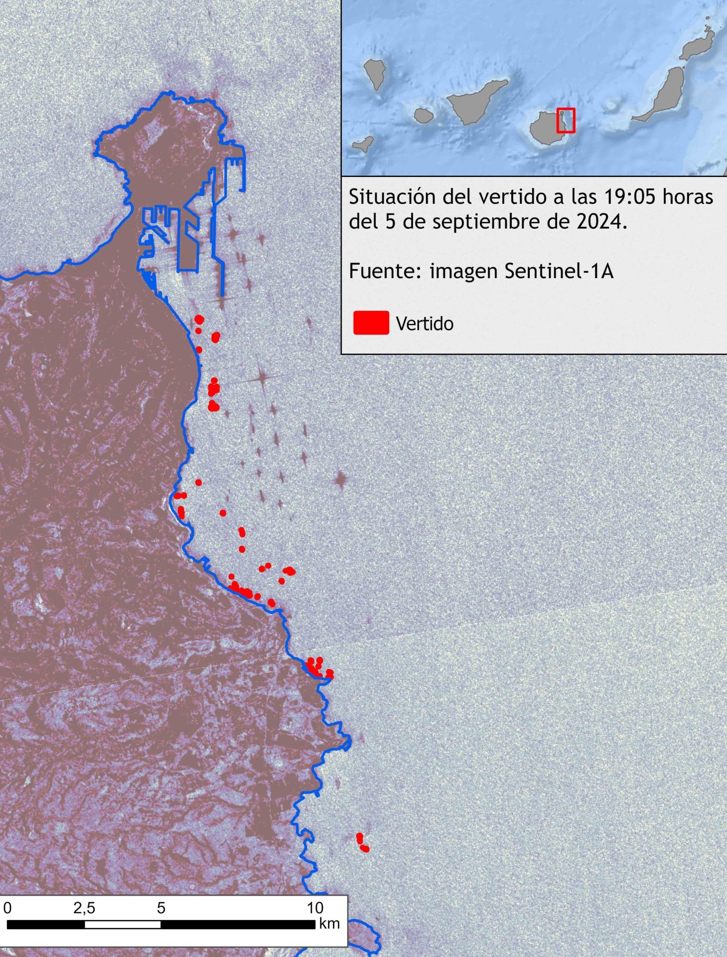 Image captured by the Sentinel-1A satellite.
This satellite captures images only every four or five days, so the analysis was repeated on 9 September, confirming that no appreciable slick was detected in the affected marine area.
According to the director of the OFYGA group, ‘this system can not only prevent losses in aquaculture production companies, but also anticipate where the troops activated by the relevant institutions should concentrate for the subsequent clean-up, depending on the level of the declared emergency, so that marine biodiversity is affected as little as possible, since the most important action after a spill occurs is to speed up the clean-up’.
The SIRENA project is an innovative warning programme based on the detection by satellite imagery of any harmful event of natural or anthropogenic origin and the subsequent calculation of its trajectory using models and methodologies that have already been successfully tested in other programmes. Approved on 22 July 2024, it will run until 22 January 2026 with a total budget of 372,000 euros, of which the ULPGC receives around 189,000.